It hadn't occurred to me until I was creating this post that all of our stops on this trip involved water. I like when a theme comes together without much effort.
This was our big yearly vacation, and we had a few different stops planned. [this will be a long post, accordingly, so get a beverage] Our first was an on-the-way stop that enabled me to check off one more state park.

Palouse Falls State Park

Me and the piggie enjoying the view and a leg-stretch.

A shady respite.

There were sunflowers everywhere. Eastern Washington feels more classically western than Western Washington. You follow?

I was just trying to get an up-close shot of a sunflower and never saw this wasp coming in for a landing.
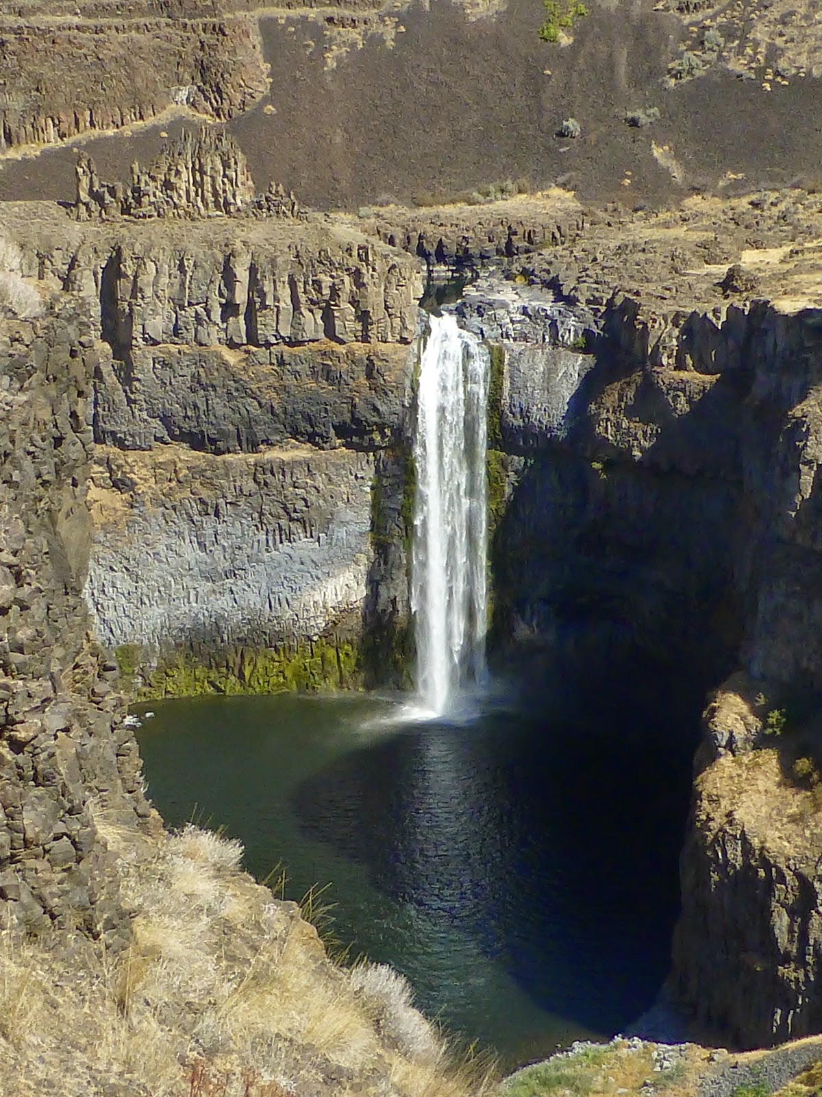
Let's take one more look before we head out. The state park website says this is 198'. The guy who kayaked over it in 2009 says it's 186'. I say, "Foolhardy at any height!"

Our first camping site was Fields Spring State Park, a remote park in the very southeastern corner of the state. This is what remains of the actual spring.

Although it's categorized as remote because it is 30 miles to amenities and there are no RV hookups, it is bordered by beautiful farmlands.

You could rent one of two teepee sites if that's what you fancied. Since the area is known for lots of bears, we did not fancy that.

Turkeys!

We took a sunset hike up Puffer Butte, so named for the Puffer pioneer family, not because of the huffing and puffing of climbing up. The story behind this picture is that I set the timer on the camera and took off running to get in the shot. Except that I didn't see the big rock right in front of me and went flying over it into the dirt. Fortunately, the dirt was quite soft and rather deep. Unfortunately, I fell out of range of the camera, and didn't get what was probably a hilarious shot of me taking a major digger.

There was a large woodstove-equipped warming shelter at the top, used more often during winter for the snow shoers and cross-country skiers.

A Slouthe of Beerys lined up on the windowsill of the shelter. These were the only bears we saw.

We matched the sunset hike with a sunrise hike up a different trail.

We started early, but should've started even earlier since we missed the sunrise proper.

The light was still beautiful, though.

Trail sign looking very much like a...grave marker. I wonder if there's a Puffer under there. Probably tripped on a big rock.

Top o' the butte to ya!
After our climb back down, it was time to pack up and head out. We really enjoyed this park -- so restful. Well, except for the mice. On the second day, I found two of Zuli's dog biscuits in one of the kitchen drawers and thought The Big Guy had put them there. But that night, we heard the critters moving biscuits around. We secured them better the next night. When we were packing up, we found two more biscuits hidden away in the back compartment. Crafty mouses! The lovely camp hostess told us about Fresh Cab, which we picked up enroute to our next location. No more meeses!

Wallowa Lake State Park, Oregon, our final destination. How do you pronounce Wallowa? We were saying wuh-LOW-uh. The camp hosts at Fields Spring said WAH-low-uh. The radio station near the park said wull-OW-uh. However you choose to say it, it is a much bigger park than we'd been to previously in the RV, still pretty packed for the time of year, although we reluctantly came to the realization that we have now joined the ranks of the "older" crowd. All of the people in RV's were mostly older than us; those in tents were younger, and there were far more RV's than tents. Very few children (which is why we take our big vacation in September each year.) Everyone has at least one dog.
It was still hot on the afternoon we arrived, and we took turns having a little swim in the lake. This lake is famous for being extraordinarily clear and clean, and until quite recently, it was the direct water source for the surrounding area -- unfiltered. It was also quite cold, and our first swim was our last swim since the weather turned much cooler after our arrival.

It was warm enough the second day for some kayaking, though.

There were several floating platforms along the east side of the lake, and we paddled to the nearest one. Obviously, the birds had beaten us to it.

There was, of course, lots of hiking in the area. We started with the Chief Joseph trail, just a little 2 miler (well, 4 since you have to count the walk up the main road to the trail head.)

This was called the Iron Bridge although it was made of wood. I don't pretend to understand some things.

I wasn't really tired.

Looking down on the lake.

Where the trail ends, but if you look across the river, you can see the remains of the bridge that used to be. Had it still been, the trail would've connected to the campground.

There was a wildfire in the canyon about 8 miles south of the park. Two days into our stay, the helicopters came, and we could walk down to the lake to watch them load up their buckets.

Splash!

This was an attempt to find the trail to the high south meadow. We basically climbed straight up a hillside for about an hour, which was really not much fun at all.

I liked this sitting part the best.

We got good views of the 'copters, though.

The other thing this park is famous for are the abundant deer that are, obviously, unafraid of humans. This was the biggest of a group of three bucks that were ever-present. He parked himself behind this RV in the sun. I guess those antlers were heavy.

One of his friends parked himself under the RV's awning. When the campers returned home, they had to step over him to get inside. He barely even looked at them. A little while later, he got up and wandered over to the neighbor's, where he helped himself to he contents of the dog food bowl.

The wildfire left us only one other option for hiking, and that was a 13-mile round trip to Aneroid Lake. Isn't that a terrible name for a wilderness lake? It means "without water." For a lake. Plus it just sounds ugly.
The Big Guy paid a neighboring tent-camper, a nice feller named James, to give us a ride up to the trail head. It was cold when we started. Freezing temps, actually.

But the steady climb warmed us up.

2.2 miles in at the dam.

We're on the right track!

In the last mile to the lake, finally not climbing so much. The alpine meadows were so pretty.

I know I look lovely here, but it's the only picture of the lake** you're going to get.

Elk cow having a snack.

One of a group of grouse. It may have been a covey, but I have no idea if it was a single family or not.

Down we go. It was much faster than up. Probably because there was a delicious milkshake waiting at the shake shack with my name on it.
**as it turns out, we missed Aneroid Lake by 1000' of flat walking. Where we stopped and lunched was actually Rogers Lake. We thought at the time that it wasn't very impressive-looking for such a hike destination, but it sure looked like the right place to sun on the rocks by some water. Google maps, once home, proved us wrong. My shin splints say I still did one hell of a hike and earned that shake.